In situ buoy data measurement
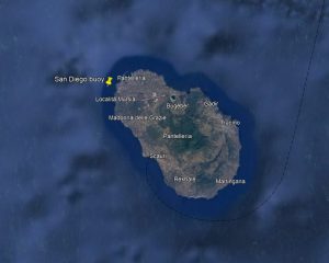
Here you can download the marine energy resource data measured by one of our wave measurement buoys located in the area of sea under concession to the Politecnico di Torino near the island of Pantelleria. The buoy is positioned at the 36.8245694 N and 11.9195901 E coordinates, shown in the following image.
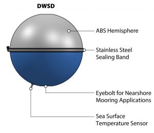
The instrument used is a Directional Wave Spectra Drifter, which is a simple wave measurement buoy developed by the Lagrangian Drifter Laboratory of the San Diego University (California). One of its main strengths is undoubtedly the hardware’s simplicity. The hull consists of two hemispheres; the bottom one displays an eyebolt for restraining in case of near-shore mooring application (it can be let free for open-ocean applications too). These measurement are used to compute wave parameters such as significant wave height, swell direction and directional spread.
If you are interested in downloading Pantelleria’s wave resource data, follow our simple guide below!
GUIDE TO USERS
You can simply download the wave data by following these steps:
- Select a time interval, specifying the “start date” and “end date” in the appropriate fields. Note that the data provided will be for 3-hour intervals starting at 00:00 on the ‘stardate’ and ending at 00:00 on the ‘end date’ (i.e. the minute after 23:59 of the day before the ‘end date’).
- Press “Get Data”.
- Time graphs over the required time period of the variables Hs and Tp appear on the screen. Scrolling below these, you will find the table with the required data, easily downloadable in .csv and excel format by pressing the appropriate buttons above the first line.
TBN:
- The data collection start on 2023-05-25 (13:00).
- Data from 2023-08-20 to 2023-11-20 (included) are absent or unreliable.
- Data from 2023-12-20 to 2024-05-12 (included) are absent or unreliable.